


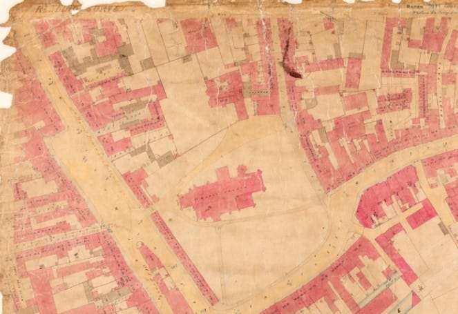
MAPS of Victorian Reading drawn up in 1853 have been published online.
Residents and history lovers can use the maps at home to explore the history of a house, street or neighbourhood in the town.
The collection of 29 maps was digitised in a partnership between Reading Borough Council’s high street heritage action zone project and Berkshire Record Office, the county archive.
Cllr Karen Rowland, borough lead for culture, heritage and recreation, said that she is “delighted” with the results.
“I’ve spent many a pleasant hour pouring over these maps at the county archive,” she says.
“They are a fascinating link between the past and present and are useful for regeneration and conservation projects, along with anyone that is curious about their own Victorian home.
“I know these maps are virtually the best record we have of Reading from that time period — so precise, you can see where the water intake and output pipes are located in each property.”
Architect and surveyor John Clacy was commissioned to draw up the maps by Reading’s board of health, as part of its public health responsibility. Under the first ever Public Health Act in the UK, passed in 1848, any town with a high death rate from diseases such as cholera had to monitor the maintenance of streets, public cleanliness, water supply and sewerage.
Mark Stevens, county archivist, said that: “Victorian Reading comes alive through these highly detailed plans.”
“They offer a chance to admire the work that the town’s engineers did and that we still rely on today to protect us.”
The maps cover the area from Oxford Road to the west, Reading railway station to the north, London Road to the east, Southampton Street and Whitley Street to the south.
Some of the outer areas of modern Reading, such as Caversham and Tilehurst, are not shown since the borough’s boundaries were smaller.
For more information, visit: maps.berkshirerecordoffice.org.uk


