


TRANSPORT for the South East has launched a new interactive map of its services, including those serving Reading and Wokingham, to help those travelling plan their journeys.
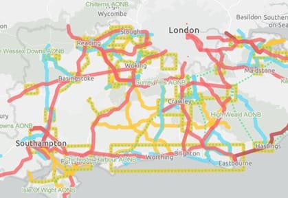
The interactive “Story Map” shows road, rail, and other mass transit routes throughout the south east, and details works which have been undertaken on the routes.
It comes as TfSE continues the implementation of its Strategic Investment Plan, put forward in Marchwhich lays out which interventions it is set to undertake over the next three years.
The SIP determines which investments are needed to support the economy in the south east, and the new map will lay out those works visually, displaying nearly 300 interventions throughout the region.
Transport for the South East’s Chair, Councillor Keith Glazier, said: “Over the last three years, a vast amount of time went into working with our partners and stakeholders across the region to figure out where investment was needed to deliver our Transport Strategy vision.
“As we put our Strategic Investment Plan into action, the Story Map will help show exactly which interventions are being delivered in each area.
“The map is a useful tool for anyone that needs to find that information quickly.”
The interactive map is available via: https://transportforthesoutheast.org.uk/story-map/

